Ontario Districts
Regional Reference Map
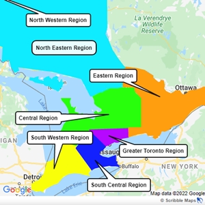
Regional Reference Chart
Atikokan, Dryden, Fort Frances, Kenora, Marathon, Red Lake, Terrace Bay and Thunder Bay.
Almaguin Highlands, Azilda, Blind River, Elliot Lake, Espanola, Hearst, Iroquois Falls, Kapuskasing, Kirkland Lake, Manitoulin Island, New Liskeard, North Bay, Parry Sound, Sault Ste. Marie, Sudbury East, Sudbury, Timmins, Valley East and West Nipissing.
Alexandria-Cornwall, Arnprior, Barry’s Bay and Area, Belleville-Quite West, Brockville and Area, Kingston, Lennox and Addington, Northumberland, Ottawa, Pembroke, Perth, Renfrew and Smith Falls.
Barrie, Central Bruce, Collingwood and Area, Dufferin, Halburton, Huntsville, Huronia, Kawartha Lakes, Kincardine and Area, Meoford and Thornbury, Muskoka, Orillia, Owen Sound and Area, Peterborough, South Saugeen, South Simcoe, Wiarton, Wingham and Lucknow.
Amherstburg, Aylmer, Brantford, Chatham-Kent, Goderich, Huron, Liderton, Ingersoll, LaSalle-Windsor, Leamington and Essex, London, Sarnia, Simcoe, St.Thomas, Statford and Area, Tillsonburg, Wallaceburg, Woodstock and Woolwich.
Aurora, Brampton, Greater Durham, Mississauga, Newmarket and Area, Toronto, Vaughan and York South.
Ancaster, Burlington, Cambridge, Dundas, Fergus, Fort Erie, Geogetown, Grimsby and Lincon, Guelph, Holdimand County, Hamilton, Kitchener-Waterloo, Milton, New Hamburg, North Wellington, Oakville, Port Colborne, St. Catharines and Welland.