Manitoba Regions
Regional Reference Map
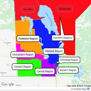
Regional Reference Chart
This region encompasses Burntwood and Norman.
This region encompasses Swan River, Hillsburg, Shell River, Minitonas, Mountain, Grandview, Ethelbert, Gilbert Plains, Dauphin, Mossey River, Lakeshore, Lawrence, Ste. Rose, McCreary, Ochre River and Alonsa.
This region encompasses Grahamdale, Siglunes, Fisher, Eriksdale, Bifrost, Armstrong, Coldwell, Gimli, St. Laurent, Woodlands, Rockwood, St. Andrew, West St. Paul, Selkirk, Rosser, St. Francis and Xavier.
This region encompasses Alexander, St. Clements, Lac Du Bonnet, Brokenhead, East St. Paul, Springfield, Whitemouth, LGD Pinawa, Reynolds, Ste. Anne, Ritchot, Hanover, Tache, De Salaberry, Montcalm, Franklin, La Broquerie, Stuartburn and Piney.
This region encompasses Wallace, Archie, Woodworth, Riverdale, Pipestone, Sifton, Albert, Cameron, Brenda, Winchester, Edward, Arthur, Whitewater, Morton, Glenwood, Whitehead, Elton, Daly, Cornwallis, Oakland, Riverside, Prairie Lakes, (Killarney and Turtle Mountain), Roblin, Strathcona, (North and South Cypress) and Argyle.
This region encompasses (Shellmouth-Boulton), Russell, Rossburn, Ellice, Silver Creek, Britle, Miniota, Hamiota, Shoal Lake, Park, Strathclair, Blanshard, Harrison, Clanwilliam, Rosedale, Minto, Saskatchewan, Odanah, Glenella, Lansdowne, Langford, Westbourne and Lakeview.
This region encompasses Portage La Prairie, North Norfolk, Victoria, Cartier, Headingley, Lorne, South Norfolk, Louise, Grey, Duffern, Roland, Thompson, McDonald, Morris, Stanley, Pembina and Rhineland.
This region encompasses Winnipeg.